It has no crew and no mind of its own, but an Autonomous Surface Vessel (ASV) is rethinking the way we approach maritime research, and it's happening in the Upper Peninsula.
The Great Lakes Research Center (GLRC) at Michigan Technological University in Houghton is the only freshwater autonomous research site in the world, and this past Monday, Sept. 9, the center launched the pioneering mission of an 8-meter ASV owned by marine robotics company, Ocean Infinity.
Data supplied by the ASV’s high-resolution sonar will aid in mapping the Great Lakes, assessing repair needs of underwater structures like harbors and bridges, and keeping shipping channels clear. It is also expected to locate multiple archaeological sites from the more than 200 never-found Lake Superior shipwrecks to remnants of civilizations that lived on the shores of a much smaller lake a thousand years ago.
At Monday’s launch, the vessel was followed by two other boats -- one, the chase boat, to track its own data while monitoring the ASV, and the other as a support to the chase.
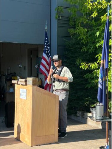
![]() Paula McCambridgeTravis White, a research engineer with Great Lakes Research Center, speaks at the launch of the Autonomous Surface Vessel.
Paula McCambridgeTravis White, a research engineer with Great Lakes Research Center, speaks at the launch of the Autonomous Surface Vessel.“The vessel’s not deciding anything. It’s either directly controlled or programmed,” said Travis White, research engineer for the GLRC. “That’s what this mission is all about — demonstrating the capabilities of this technology. Five years from now, we could be shoving it off the dock and, instead of remotely controlling, we’re concentrating on remotely monitoring.”
GLRC is a member of the Great Lakes Smart Ships Coalition, an international group that shares an interest in promoting autonomous vessels in research in the Great Lakes, which is exactly what Monday’s effort was.
This first time out, the ASV mapped a 20-square-mile patch of the lake. Twenty square miles is a lot of ground to cover, but to put it in scale, Lake Superior is about 34,000 square miles total, so this is just the beginning. Eventually, researchers plan to map all five of the Great Lakes as part of the
Lakebed 2030 project.
Researchers say the technology will also eventually bring answers to decades-old questions involving the whereabouts of more than 200 unaccounted for shipwrecks and plane crashes in Lake Superior alone.
Knowing that the public leans into a good mystery, one was included in this launch.
“We want to demonstrate to the public how this technology can be useful, and what better place to start than with a mystery that remains unsolved,” said John Schmidt, who is program manager for the Great Lakes St. Lawrence Governors and Premiers — a group of leaders from the US and Canada who, in partnership, manage and preserve the Great Lakes.
The 20-square-mile mapping region was selected because it is believed to be the most likely place to find debris from a plane crash that vanished without a trace in October 1968. The craft was a National Center for Atmospheric Research plane carrying two pilots and a graduate student. It was on a routine data-collecting mission when it went silent after its last contact with the Houghton County Memorial Airport in Calumet.
Besides a few isolated pieces of debris that were netted by fishers or washed ashore, the plane was lost, and no one knew why.
“I’ve been in touch with the pilot’s family, and they’re interested in what happened. There’s something about losing someone — we want answers,” said Wayne Lusardi, maritime archaeologist for the state of Michigan. “The goal this week is to find it and then clearly identify it as from this plane.”
Once the craft has been located and identified, there will be following steps with multiple agencies involved to decide how to process what would now be considered a historic site. If any remains are located of those who died aboard the plane, their families will be involved with deciding how to proceed.
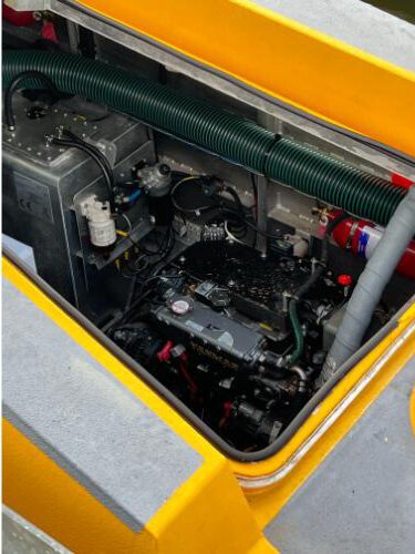
![]() Paula McCambridgeA look inside the Ocean Infinity Autonomous Surface Vessel that launched from the Great Lakes Research Center at MTU Monday.
Paula McCambridgeA look inside the Ocean Infinity Autonomous Surface Vessel that launched from the Great Lakes Research Center at MTU Monday.“We expect to find something this week,” Lusardi said. “It’s not going to be an intact plane but more likely a debris field. If we don’t find it this week, with today’s technology, it’s just a matter of time until we do. When the lake is mapped, we’ll find it, and if we can find this, we can find anything. It’s exciting to work with this state-of-the art technology.”
The search area for the current demonstration is between 300 and 400 feet deep — at its deepest, Lake Superior is 1,332 feet. The sonar with its high-resolution images is the first data point with other technology used in support.
“If we see a target that interests us, we can use a suitcase of technology,” White said. “We can use cameras or a tethered remote vehicle like a rover that sends back data.”
Daily updates and live streams are appearing on the
Great Lakes Observing System YouTube channel.
“We know more about the surface of the moon than the ocean,” Schmidt said. “The same is true of the lakebed. The biggest message to convey is, there’s more to come.”
The mission is planned for about four-and-a-half days of surveying wrapping up this Friday, Sept. 13.
Bringing autonomous vessels to the Great Lake doesn’t happen without vast teams and partnerships.
First, there’s the third-year MTU undergraduate Jenna DeVries, majoring in mechatronics, which combines mechanical engineering with electrical and computers. She’s the ASV project’s first student intern and part of the next generation who will be carrying on this work.
“It’s a lot and cool to be doing all these projects, then Travis (White) and Chris (Pinnow, engineer) ask me, ‘You know what you’re doing, right? You realize what you’re a part of?’ I’m hoping, eventually, to get a job here and stay — that’s the dream.”
Partners and financial backers include Great Lakes St. Lawrence Governors and Premiers, Ocean Infinity, Michigan Technological University, NORBIT, National Museum of the Great Lakes, Michigan Economic Development Corporation, Michigan Office of Future Mobility & Electrification, Michigan Department of Environment, Great Lakes, and Energy, Great Lakes Shipwreck Historical Society, Great Lakes Observing System, Interlake Maritime Services, and Kongsberg.
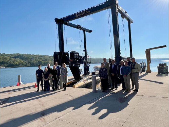
![]() Paula McCambridgeAutonomous Surface Vessel project partners representing academia, government, technology, and finance gathered Monday for the ASV launch.
Paula McCambridgeAutonomous Surface Vessel project partners representing academia, government, technology, and finance gathered Monday for the ASV launch.“This technology makes lake exploration more accessible. It will never replace a crewed vessel but does the dull, dangerous, and dirty tasks at sea, the tedious work of going back and forth,” White said. “My hope is that this demonstration will excite public interest and investors. We’d love to keep this in the water.”
The project is the first of a series of planned tests showcasing the diverse applications of autonomous technology in the Great Lakes.
Paula McCambridge has been writing and editing for more than 25 years. She won her first awards for feature writing and ongoing news coverage at the Daily Mining Gazette in Houghton, Michigan.