Before there was Google Maps on your iPhone, there were paper maps and compasses.
Those tools still exist, of course, but a newly completed Orienteering and Land Navigation Course in Isabella County allows the adventurous to test their skills to navigate the landscape with -- you guessed it -- a map and compass.
The final instructions, maps and lane cads for the respective courses were completed and added to the Isabella County Parks website this past spring.
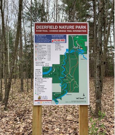
The 20-point Orienteering and Land Navigation Course is located in Deerfield Nature Park, just west of Mount Pleasant. The 591-acre park is the largest and busiest hiking park in Isabella County, attracting thousands of visitors each year.
"We have had a great response from community members and park users. Many are interested to know what Orienteering and Land Navigation are and how they can go about trying out the course," said Rachel Rollin, administrative assistant for Isabella County Parks and Recreation. "We have also had local hoteliers interested in promoting this new course to their guests as another fun activity to enjoy while visiting the Mt. Pleasant area."
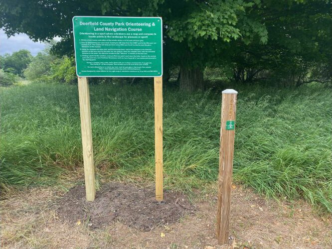
![]() The Orienteering and Land Navigation Course formally opened to the public last fall.
The Orienteering and Land Navigation Course formally opened to the public last fall.
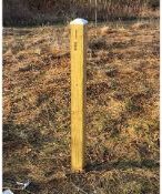
The county parks department added nine wayfinding, “You Are Here,” signs to the park this past spring to help visitors navigate eight miles of nature trails.
What’s happening: The final instructions for the Orienteering and Land Navigation Course were added to the Isabella County Parks website this spring. The 20-point Orienteering and Land Navigation Course formally opened to the public last fall.
About the course: While the Orienteering and Land Navigation are on the same course, the course is used differently depending on Orienteering or Land Navigation. The start of both courses is positioned on the north end of the park just south of M-20.
For the Orienteering course, participants start by choosing between six easy courses, three medium courses, three hard courses and two expert courses.
![]()
The Land Navigation course offers 21 preset courses for daytime and nighttime including 16 non-self-correcting difficult courses and five self-correcting easy courses.
Instructions on how to use the course for orienteering can be found on the
Isabella County Parks website. Visitors can also ask for maps and lane cards at the Deerfield Nature Park gatehouse.
What is orienteering: Orienteering is a sport in which people use an accurate, detailed map and a compass to find points in the landscape for pleasure or sport. No experience is necessary to navigate an orienteering course. Land Navigation is the discipline of following a route through unfamiliar terrain on foot, using a map of the terrain, a compass, a protractor, and other navigational tools to find points in the woods. Land Navigation requires some training.
How difficult are the Deerfield Nature Park courses: Both the orienteering and land navigation courses offer various levels of skill based on experience and ease. “We have courses for all skill levels. Whether you are a beginner trying the “easy course” or an advanced orienteer trying the “hard course” or “expert course,” the park offers different levels of difficulty depending on experience,” says Miranda Walker, interim director for the county parks department.
How the project began: The course was part of an Eagle Scout project organized by Lukas DiMaria, a member of local Boy Scouts of America Troop 604. The materials and a large portion of the installation work were supplied by DiMaria. Isabella County Parks staff also assisted with the project, particularly providing input on the course layout, labeling the posts, and post installation. Trent Esch of Central Michigan University’s Army ROTC also helped. The
Central Michigan University’s ROTC program is expected to be among the course users.
![]() What’s next:
What’s next: The Isabella County Parks and Recreation Commission installed five more wayfinding signs this summer in non-trail areas of the park, including the sledding hill and near the beach.
In addition to the wayfinding signs, color-coded trail blazes were added to all the trails south of the main trailhead as part of an Eagle Scout Service Project organized by Eli Buccilli of local Boy Scouts of America Troop 604.
Funding: Funding for the wayfinding signs came from the
Rotary Club of Mt. Pleasant, Rotary District 6310, and the
Mount Pleasant Area Convention and Visitors Bureau.
The Orienteering and Land Navigation Course is located at the Deerfield Nature Park, 2425 W. Remus Road. The courses are open 8 a.m. to dusk daily and free to the public; however, there is a daily park entrance permit for $6. Annual permits can be purchased for $25 to $35.
Jason M. Karel is a freelance writer based in northern Michigan.
Enjoy this story?
Sign up for free solutions-based reporting in your inbox each week.